Pages

Saturday 21 July 2012

GW/SW 015

Mynydd Llangorse 515m ,  2 points

Association: Wales, Region: South Wales

Latitude: 51 55 56 N, Longitude: 3 13 28 W

OS Grid Reference: SO 159267 

Locator: IO81JW

Today Saturday 21 July 2012 Mal (GW6OVD) and myself (MW0PJJ) planned to activate this summit for around 10:00 am UK and 09:00 UTC. With travelling time of 45 minutes from home we arrived at the foot of the summit at 9:10 and started our assent.

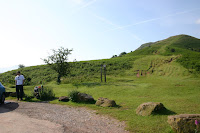
The parking at the foot of the summit can be tight at busy times, room for about 5 cars. Good access roads leading to the car park. Take care there are many walkers in the area and the road has many blind spots.
The first section of the walk climbs at a steady pace and increases rapidly until the first section then a gentle climb to the summit

There is plenty of room at the summit to setup equipment.


Contacts were made with the following stations

2W0ZJA         -       David
M06MMM        -       Mike   Summit - Summit G/SP004 Shining Tor
G4NFS            -       Norman
GW1VAB/M     -       David
2E0ZVR           -       Barry I091AW

      
TBC.


Saturday 7 July 2012

GW/MW-002


Great Rhos - 660m, 4 points


Assocation: Wales, Region: Mid Wales

Latitude: 52.267101287842, Longitude: -3.2000999450684

OS Grid Reference: SO18217 63895,   Locator: IO82JG


For this SOTA outing we decided to activate Great Rhos, the flat topped summit of the Radnor Forest. Present at this activation was Mal (GW6OVD) and myself Andy (GW7RKC).


The 13th century Haines Mill, our start point on the A44
We set out from Aberdare at 9.30 and arrived at  our start point on the A44, some  4.4km South East of the summit at  11am. This location is the site of the Haines Mill,  which has had a watermill since the 13th century. The mill itself was closed but we were able to park where the mill stream runs under the road. 


We gathered together our gear and went through the metal gate to the left of the mill site. A small road took us Northwards alongside a stream. The stream was in full  flow due to the heavy rain that we had experienced in the previous week. 


Mal crosses the bridge at the beginning of the ascent
After a short walk  we arrived at metal gate with signage warning us that the road was closed to the general public. We then followed a bridlepath sign to the left of the road which led us to cross the stream using a wooden bridge. At this point the path started to ascend the hillside at a steep incline.


Getting steeper...

 The weather had been very wet in the days and weeks prior to this activation but still we hoped that the rain would hold off.  The sky did not look promising!


Incoming!!
As we continued on, there were plenty of signs warning of the dangers of straying from the path. The area is used for live munitions testing!


Andy takes a breather.
Mal and I agreed that this was one of the more physically demanding summits we have tackled. It was a steep ascent nearly all the way and frequent breaks were needed to allow us to catch our breath!


Nearly there.
Nearing the summit we went through a metal gate and then decided to travel 'line of sight' toward the trig point. On reflection this was a mistake, the ground was rutted, boggy and very difficult to negotiate. We later discovered that had we followed the fence we would have eventually encountered a trail which would have made  things much easier.


Antennas Up!
We reached the summit at 12.40 and wasted no time preparing for activation. The 'old faithful' 2m SlimJim was mounted using the trig point for support. The 40m dipole was also assembled.


Mal had brought a small popup beach tent which served  to make the activation quite comfortable, enabling us to keep warm and also keeping the Mic wind noise to a minimum. We fired up the ft817 with a 30w linear and the contacts came rolling in thick and fast. It wasn't long before we had both gained  four contacts for activation. The weather was being kind considering the very wet summer we'd been having so we pressed on with the task of filling up our log books. The only minor disappointment was 40m as the band conditions seemed poor with many 'static crashes' presumably from nearby electrical storms.


Operating in comfort..


Sunshine
At 2.30pm we decided to call it a day and began to pack up. As we made our descent the sun occasionally peeked through the clouds and we were rewarded with some great views of the surrounding countryside.


As always , Mal and I would like to thank all the contacts who contributed toward this activation. 

Best wishes and 73,

Andy - GW7RKC


Route Taken


Thursday 5 July 2012

GW/SW-019


Mynydd Twyn-glas - 472m, 1 point


Association: Wales Region: South Wales
Latitude: 51 40 26 N, Longitude: 3 4 22 W
Grid Reference: ST 259978, QTH Locator: IO81LQ


For today’s summit we chose Mynydd Twyn-Glas,  which overlooks the town of Cwmbran and has great views out over the Bristol channel.


The road meanders up to the summit
Parking up by the cattle grid at ST236-980 Andy and I sat in the car for a few minutes until the rain passed.  There’s a rough road from here, winding its way up alongside the overhead power lines to the masts near the summit


Some fine views on the way up.


The wind was howling through nearby masts and pylons!
As we neared the masts the wind was howling through the nearby pylons and continued strengthening as we approached the trig point at the summit.


A windswept summit trig point...
After struggling with the antennas for a while we looked around for a more sheltered spot and saw the ruins of a small building to the east, so we decided to set up there.


Andy gets 2m underway

We quickly managed to lash the vhf antenna to the building and Andy kicked off on 2 meters while I got the 40 meters inverted V ready for action. 


Mal doing fine business on 40m with the FT-817

Once up and running it didn’t take long to get enough contacts for our activation, starting on 2 meters, half an hour or so on 40 meters and finally finishing up back on 2 meters before the sky’s began to blacken.
We took the hint and quickly packed up before heading back to the car.


40m Dipole (left) and VHF JPole (On Building)


Our route to the summit.


Many thanks to all stations that helped with our activation of Mynydd Twyn-Glas and made this a  thoroughly enjoyable day for both Andy and myself.


73
 Mal  GW6OVD